Colorado
Date: Friday, August 27, 2010
Peak: Mt. Elbert
Height: 14,440 feet
Vertical Climb: 4850 feet
Round-trip Mileage: 11.5 miles
Peak Class: #6
Height Rank: #3 of 50
Difficulty Rank: #9 of 50

BASECAMP

(Mt. Elbert Lodge was originally a stagecoach stop during the mining days. It made a wonderful basecamp for the climb.)

Although not a true 4-wheel drive, the vehicle did pretty well but about one mile up we felt we had gone as far as was safely possible and parked and did some walking up the old road. We found another spot a little further up and Devin marked it on his GPS system. On the way back we had some problems getting out of our parking spot and, at one point, Devin was driving on only three wheels. It wasn’t an all-terrain vehicle, but it did ok. There was one spot coming back down, though, where the vehicle was literally sliding down the road on the loose rocks.
(One of the better sections of the 4-wheel drive road--Devin did an admirable job with the all-wheel drive vehicle. Not too bad for a flatlander.)

(Three wheels on the ground and one in the air: The two-mile dirt road was in terrible shape but we made it about half-way up which cut two miles round-trip off our hike)

(An apocalyptic message carved into one of the aspen trees. Mt. Elbert was tough, but not that bad!)
 We returned to Twin Lakes and got some food to go at the Windspirit Café and returned to the lodge and ate outside on the back porch with a babbling stream beneath us and a beautiful mountain stream in front of us and a granite wall of mountain literally rising above us from the stream banks. This is one of the most beautiful spots I’ve ever seen in Colorado (I would change my mind the next day from the summit of Mt. Elbert). The weather had been beautiful and was supposed to hold for our ascent day.
After walking around a bit, we went to bed early. I went to sleep ok but woke up at 2:15 and never went back to sleep—making me tired when we set off that morning. It got down to 41 degrees that morning and we slept with two windows open but the quilts on the beds kept us warm. The Mt. Elbert Lodge is a bed and breakfast but they put out a “hikers breakfast” the night before for us so we ate a light breakfast before taking off around 5:15 am.
(Mt. Elbert in the distance--five and one-half miles away. Didn't look so tough from here)

(We parked at 5:50 am and started up the road about 40 minutes before sunrise. We had a full moon but still needed a flashlight in the woods.)

(The official trailhead marker--it was still pitch dark at this point)

There it was just getting daylight when we crossed over the wooden bridge and “officially” started the ascent of Mt. Elbert. Shortly along the trail we reached a “Y” where the Colorado Trail went to the right and the Mt. Elbert trail to the left. From here, the trail was through wooded pine and aspen trees but became steep very quickly.
(Twilight had become sunrise by the time we made it up the 4-wheel road to the footbridge marking the trailhead)

(Early on, Devin had excess energy and jumped up on this boulder for the photo. Eleven hours later, coming down, he barely looked at it)

(Although the wooded trail was mostly dirt--it was still uphill and at times could be very steep)

I felt the first hour went pretty well and my breathing actually acclimated to the altitude quicker than I had in New Mexico three weeks earlier and after about two hours, we broke out of the wooded area at the Alpine treeline—around 12,000 feet.
(Break time--we were both still feeling energetic and good but it would start to get harder from this point)

ALPINE AREA
At this point, Mt. Elbert was still a faraway mountain peak, but we continued hiking upward. The landscape was barren but did have a grassy cover here. My new boots were feeling good and I really appreciated having the new trekking poles with me at this point.
(You can see the delineation between the grassy alpine area and the rocky glacial trail. This was my first experience with trekking poles and I fully endorse them.)

At around 12,500 feet I started having trouble breathing again which slowed our pace but I still felt pretty good about our progress. We were beginning to encounter other hikers who were coming up behind us and going faster. All were very nice but one guy just couldn’t believe Devin was climbing in running sockwear. Already, at this point, I was slowing our progress down but Devin didn’t seem to mind. He was wearing his triathlon Garmin GPS wrist tracker so we knew our altitude at all times and we also were carrying a spot tracker so others could plot our progress on the Internet.
(Looking back at 13,000 feet--Twin Lakes is out of sight below the crest)

At one point we met a young couple who were climbing the peak on her birthday—which was basically what I was doing too. They were real nice and we talked a bit then they took off ahead of us but I could see she was really struggling too.
(Around 13,000 feet the views were becoming spectacular)

We continued up through what I call the “alpine area” and the views kept getting more and more spectacular the higher we climbed. At 14,000 feet we stopped and took a picture of Devin’s altimeter. At this point I was really struggling with my breathing and, while my legs were tired, I still felt pretty strong. I think we were about 4.5 miles into the hike at this point—all uphill of course. The next two miles would be killers and I would wonder several times if I’d bitten off more than I could chew with this adventure.
(This was a watershed moment: I had never officially climbed over 14,000 feet before--we could now truthfully say we were "fourteeners.")

By now, because of the thin air, I was only hiking about thirty steps then having to rest and breathe—so the progress was frustratingly slow. This was the same thing that had happened to me on Wheeler Peak three weeks earlier, so I knew what to expect and I knew that if I just kept going, I would eventually make the peak. I told Devin it was ok if he wanted to go ahead of me and summit and wait for me there but he was really considerate and stayed with me. I’m sure he could have summited at least two hours ahead of me if he had gone ahead.
GLACIAL AREA
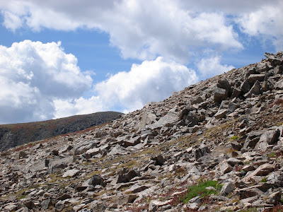
The alpine trail wound around until it became what I called a “glacial area” with no grass and rocks and boulders strewn around everywhere. As we worked our way around the curvature of the mountain, we finally caught sight of the summit again only about 400 feet above us but it was one of the most heartbreaking discoveries of the whole climb—that 400 vertical feet would take nearly two hours of absolutely miserable step-after-step climbing on rock switchbacks. My legs had long ago gone from “greyhound mode” to “bulldog mode” and I was literally struggling to do 25-30 steps without stopping to literally “suck air.” And, while I still felt strong, my legs had really begun to tire on me.
(Although there were no truly "dangerous" areas, we did encounter some dramatic drop-offs as evidenced by Devin's feet in this photo. He hiked the entire trail in these "running socks." Several hikers voiced dismay he would do it--I had some reservations too but he said they did just fine.")

(Although Mt. Elbert has no true "false summits," this was the view after four hours of hiking. Thinking we were close, we realized Elbert was the peak in the background. It is the one point in the hike where I wondered if I was going to make it to the top.)
 Devin continued to be patient with our progress and stayed with me. We also continued to meet other hikers ascending and, at this point, some we had met earlier who were now coming back down. It seems that every major climb like this presents a strange occurrence. On Wheeler Peak, it had been a jogger going past me at over 13,000 feet up the mountain, but on Mt. Elbert it was even stranger.
(At this point, there was nothing left to do but "gut it out")

We were getting very near the summit when we looked up and a Japanese guy was literally running down the mountain jumping from large rock to large rock. What struck me first was that he was wearing white linen pants with a white silk vest and a white Fedora hat (1930s style). As he reached us, I also noticed he was wearing white dress loafers and was carrying a purse (or, as they call it in Europe: a “manbag”). He flagged Devin down and asked what trail he was on—he had summited Mt. Elbert in dress clothes and then gotten turned around and headed down the wrong trail!!! When he figured that out, he turned around and began running back up to the summit. I mean he was literally running—I could only stand there gasping for air and watch him in amazement.
We continued upward and by now, my body was operating on “auto pilot” while I was literally placing one foot in front of the other and forcing myself upward. But finally, I rounded a switchback and could see the summit in front of me. We arrived almost exactly seven hours after leaving the trailhead.
(This is the final view before summiting--my feet and boots felt like they weighed thirty pounds each at this point)

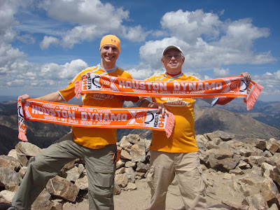
SUMMIT (14,440 feet)
(Modern technology--Devin's hand-held GPS system was accurate to the foot despite being nearly three miles above sea level)

I will never forget the experience of viewing the mountains from Mt. Elbert! Here, we were at the highest point in Colorado; the highest point in the Rocky Mountain chain; and the third highest state highpoint in the United States—14,440 feet above sea level. You may experience it, but you can never really describe it. The weather had not just been good; it had been uncharacteristically beautiful and there were no storm clouds anywhere in any direction. I later read that, on a clear day, you can see literally hundreds of miles from the summit and we had a beautifully clear day.
(Twin Lakes is below Devin and Texas is far, far away behind him)

There are four major trails leading to the summit and approximately 12-15 people were there when we arrived—including the couple celebrating her birthday. It’s funny, but when you get up there, people tend to separate and find a solitary place and just sit looking out by themselves for a few minutes. We
saw three dogs that had climbed with their owners to the summit.
(There were about 12-15 people at the summit but people were, for the most part, very solitary and quiet--the views were in themselves very awe-inspiring)

Devin and I spent about 45 minutes up there taking pictures and just admiring the beauty. We got pictures of ourselves with our Dynamo jerseys and shot photos of the survey marker—the official “summit” of Colorado and the Rockies. I shot a couple of panoramic videos of the surrounding mountains and it was strange to view those massive “fourteeners” and realize they were all below us.
(Of course we had to show the colors!)
There was a clear view of Leadville below us and, amazingly, the cell tower there was unobstructed and people were getting crystal-clear cell phone coverage! Devin had five bars on his phone and called Alida from the summit. With cell coverage, everybody had Internet on their smart phones and was emailing pictures from their cell phones. We have very much become a technological society.
(They claim you can see a hundred miles from here on a clear day)

I personally sat down behind a rock cairn to get out of the wind and just soaked in the spectacular and amazing beauty all around me. We only saw one chipmunk up there but he knew how to beg for food and loved our salted almonds—but wouldn’t touch my powerbar.
(He loved our salted almonds but wouldn't touch my PowerBar--probably shows good taste on his part)

I had hydrated well on the way up—four pints of water—but had eaten hardly anything and didn’t have any appetite. I tried to force myself to eat some jerky and part of a powerbar but that was all I could do. I may have been experiencing “altitude sickness” to some degree but never got a headache.
(Devin at the top--the weather was just perfect!)

There is an old saying: “summiting is optional; but returning to base camp isn’t.” So, after 45 minutes, we were the only ones left and we started back down. The trip back took longer than either of us anticipated—four hours and fifteen minutes—and was not a fun experience but we arrived back at the car 11 hours and 54 minutes after setting out that morning. We had hiked 11.5 miles and ascended a total of 4,545 feet in the first seven hours—not particularly good time but, for me, a personal best. Devin is a ultra marathoner and triathlete and even he admitted he was beat when we got back to the car. After pulling my boots off, we drove back down the 4-wheel drive road very carefully, got some food to go at the Windspirit Café, and returned to the lodge again to eat supper outside at the base of Mt. Elbert.
Just an incredible experience!!!!!
No comments:
Post a Comment